Canadian Naval Exercises and Drones
There was an interesting report recently about the use of drones in a naval exercise off of Nova Scotia. Alison Auld, in writing about success in finding and tracking North Atlantic Right Whales (see “High-tech drones prowling Atlantic waters may have found elusive whale habitat”), noted that glider-type drones were employed in the Navy’s CUTLASS FURY exercise “to gather acoustic data and help with marine mammal detection.” The Royal Canadian Navy (RCN) has long used unmanned and remote-controlled air, surface and underwater vehicles as targets and for hunting naval mines. This time, the use was a bit different, at least publicly reported, and is a sign of the rapidly developing use of drones by navies.
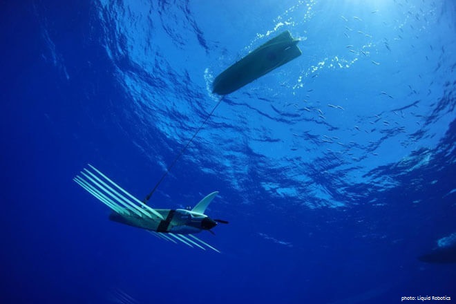
In September, Maritime Forces Atlantic (MARLANT), a formation of the RCN, conducted CUTLASS FURY (CF 16), a major multi-national exercise with a significant focus on open ocean naval operations. Ahead of CF 16, Wave Gliders were employed as part of the Marine Environmental Observation Prediction and Response Network’s (MEOPAR) Whale Habitat and Listening Experiment (WHaLE). Wave Gliders are unmanned wave- and solar-powered sea-going vehicles. The objective of WHaLE was to detect the presence of marine mammals in the area of the exercise. In co-operation with Trinity, the RCN’s information management centre, and MARLANT’s Formation Safety and Environment Branch, the WHaLE project planned a glider deployment through the CF 16 operating area prior to the arrival of naval ships and aircraft, to screen for the presence of four species of vocalizing baleen whales, including the threatened North Atlantic Right Whale. The Right Whale is a concern to the RCN as the animal has suffered from frequent collisions with ships. The WHaLE project reported findings to MARLANT prior to exercise start, which assisted planners and operators in mitigating harm to the whales during the exercise. Sea data (temperature and salinity) collected during deployment of the gliders were input to ocean models, specifically the Global Ice Ocean Prediction System and Mercator Océan. Products generated from model data were provided by MARLANT’s Meteorological and Oceanographic Centre (METOC) to CUTLASS FURY participants as they would be for any allied ship operating in the MARLANT area.
So, in addition to long time routine use of drones as targets, and more recent use of drones in the specialized, and complicated, field of mine warfare, there is now this example of drones being used to assist with the environmentally safe conduct of an exercise. Further, the information being collected was operationally useful. The sea data from the gliders is the sort used in the search and localization of submarines (though oceanographic staff express such confidence in their models based on many years of collection that the glider data is just looked upon more as confirmation of the models’ data). Ultimately, anti-submarine warfare (ASW) was a major part of CF 16, as it will be for future CUTLASS FURIES and other major naval exercises. Drones will play a major role in ASW and in other warfare areas.
The United Kingdom Royal Navy is conducting Exercise UNMANNED WARRIOR this fall to “experiment and demonstrate the potential offered by maritime autonomous systems.” It can be envisioned that future naval exercises, Canadian and foreign, will have even more drone participation, by air, surface and underwater vehicles. This participation will considerably change the way naval exercises are planned and executing, but more so will be opportunities for the RCN and the Canadian Armed Forces to develop the equipment, doctrine and procedures for use of drones in future naval operations. At some point, the drones will likely be in the majority.


