The Canadian North, our Airspace, its Surveillance, Air Traffic Control and Search and Rescue – Is Canada doing enough?
by Murray Lee and Ed Young
With the onset of global warming, more and more of Canada’s north is becoming open and accessible due to the “melt.” At the current rate of warming, the Northwest Passage and other routes will soon be waterways open all year. More sea lane traffic will result and with that comes the possibility of accidents and the need for rapid northern search and rescue response, both from the sea and the air. In this article however, we are not going to discuss the sea issues around our northern landmass as this will be dealt with in another RUSI(NS) paper later this fall in the Canadian Naval Review. What we wish to discuss here is what is happening overhead – our airspace. Newly launched satellites providing total coverage of the north is a tremendous technological advance and as a result, more and more air traffic will result as domestic and foreign carriers will transit our northern airspace to cut time and costs on their overseas routes. RUSI(S) is currently looking at air aspects of our northern sovereignty and this short primer will address some, not all, of the issues with respect to the airspace over Canada’s north coupled with a need for robust search and rescue resources.
Territorial Airspace
Territorial Airspace is defined as “…that portion of the atmosphere controlled by a country above its territory, including its territorial waters…”
The issue of territorial sovereignty is addressed in the United Nations Convention on the Law of the Sea (UNCLOS) and the Convention on International Civil Aviation (the Chicago Convention, or CC.) Although UNCLOS is titled “Law of the Sea,” its provisions also affect airspace and the operation of aircraft. Under international law, a country’s airspace is considered to be twelve nautical miles (NM) out from the coastline of a nation, but does not include outer space.
By the CC, outer space is defined by what is known as the “Karman Line” which is the boundary between the earth’s atmosphere and outer space and which is set at an altitude of 100 kilometres (km) (62 miles).
Exclusive Economic Zone (EEZ)
Most of us know about the Canadian EEZ as it pertains to fishing rights and other maritime activities – but what about the airspace overhead? EEZ is a concept adopted at the Third United Nations Conference on the Law of the Sea (1982) whereby a coastal state assumes jurisdiction over the exploration and exploitation of marine resources in its adjacent section of the continental shelf, taken to be a band extending 200 miles from the shore. EEZ only have material effect on maritime resources, including the sea bed, and do not have any “legal consequences” for aviation (UNCLOS Articles 57 and 58).
National Airspace
“National Airspace” only composes the land and territorial waters, therefore, the non-sovereign portion of airspace is beyond this as far as aviation is concerned (i.e., 12 NM, CC Article 2).
The volumes of airspace are dependent on the definition of “baselines” in UNCLOS, which are generally based on “….the maritime shoreline, whether the shore is continental in nature or the outermost part of a chain of islands (an archipelago). However, not all island groups are archipelagos, as the islands must be no more than 100 NM apart to meet the definition ….”
Archipelagic Waters
The UNCLOS convention set the definition of Archipelagic States in Part IV, which also defines how the state can draw its territorial borders. A baseline is drawn between the outermost points of the outermost islands, subject to these points being sufficiently close to one another. All waters inside this baseline are designated “Archipelagic Waters.” The state has sovereignty over these waters (like internal waters), but subject to existing rights including traditional fishing rights of immediately adjacent states. Foreign vessels have right of innocent passage through archipelagic waters (like territorial waters).
Therefore, archipelagic waters and the airspace above them are sovereign and part of the territory of the state concerned (CC Article 28 – provision of air navigation services). However, sovereignty of archipelagic airspace is not the same as other territorial airspace, as aircraft have the right of “continuous and expeditious” passage, and so cannot be denied transit through this area (UNCLOS Article 53).
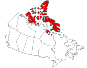
The Arctic Archipelago
Lying north of mainland Canada, the Arctic Archipelago consists of 94 major islands (greater than 130 km2) and 36,469 minor islands covering a total of 1.4 million km2. Apart from Greenland, which is almost entirely ice covered, the Canadian Arctic Archipelago forms the world’s largest High Arctic land area.
In 1999 most of the Arctic Archipelago became part of the new territory of Nunavut, which has its capital and legislature in Iqaluit on Baffin Island.
Air Traffic Control (ATC) in the Canadian Arctic
Most of the Canadian Arctic airspace has been controlled by Canadian ATC since the post-war era, and the northern Canadian airspace is contained within the Edmonton Flight Information Region (FIR). By definition, a “FIR is a specified region of airspace in which flight information services and alerting services (ALRS) are provided …..”
FIR boundaries were established by International Civil Aviation Organization (ICAO) convention, and signatory countries agreed to provide flight services and to publish their FIR boundaries in a Designated Airspace Handbook (DAH). To ensure flight planning accuracy, the boundaries must be in both print and digital format with a latitude and longitude co-ordinate data base. Canada’s printed version of the DAH is Transport Publication 1820 (TP1820), available in both English and French.
Countries also agreed to update their DAH in accordance with the Aeronautical Information Regulation and Control (AIRAC) cycle. AIRAC updates depict changes to aeronautical data bases, and are required to be published every 56 days as scheduled by ICAO. These AIRAC cycles ensure that all computerized flight planning systems are kept up to date world-wide.
The Edmonton FIR boundary is depicted in TP1820E (in part) “…beginning at 57N 13204W…thence northerly along the Canada/Alaska boundary to thence northerly along the 141W longitude to the geographic North Pole (90N 141W)….thence to 82N 060W….to 78N 075W …..etc.” The boundary then continues south and eastbound until it meets the northern edges of Winnipeg, Toronto and Quebec domestic FIR boundaries. There is no mention of “sovereignty” in the ICAO protocols that refer to Air Traffic Control (ATC) jurisdiction in FIR. In fact, some FIR encompass several countries, e.g., Africa consists of 54 countries but there are only 35 FIR in Africa.
ATC Services Costs
As an interesting aside, Canadian ATC international overflight charges are quite high compared to other countries – the overflight fees are calculated by the following formula:
Fee = R X W X D
where R is the set rate; W is the square root of the aircraft maximum Take-Off Weight (MTOW) in metric tons, and D is the total great circle distance in Canadian airspace in kilometres.
Overflight fees are being charged for certain flights that originate in the United States and fly over Canada. Fees apply to flights from a US airport to two or more Canadian airports to Alaska, and from a US airport via Canadian airspace to Asia or Europe. The current set rate is $0.026142. For example, an A330 aircraft with an MTOW of 136.08 metric tons would be charged approximately $0.40 per km. If a Delta Air Lines A330 departed Portland, Oregon, bound for Europe, the flight path would travel about 3600 km in Canadian airspace and the fee would be about $1500.
With the advent of long-haul polar flights, the Edmonton FIR is a significant source of revenue for NavCanada (NAVCAN). Flight planners use an analysis program to ascertain whether higher aircraft operating costs for flights that would fly longer, but via non-Canadian airspace routes, would be cheaper than paying overflight fees. On average, large aircraft operating costs are about $125 USD per minute.
Normally, air carriers do not mind paying overflight fees if the flight path saves flying time – overflight fees are significantly less than aircraft operating costs. Air carriers consider overflight fees as a “cost of doing business” and are added to ticket prices the same as airport fees, customs officer fees, health and animal inspection fees, crash fire rescue (CFR) fees, etc. Polar flights over Canadian airspace save countless hours of flying time and are preferred routes between North America and Europe.
We have now reached an interesting point in our discussion. What about the cost and availability of search and rescue (SAR). NAVCAN does not provide SAR services, the Department of National Defence (DND) does. Drilling down on this subject, if overflight fees are collected by NAVCAN for ATC services, would it not be feasible to charge a similar fee for SAR services? SAR operations in Canada are quite expensive, especially considering the large amount of territorial airspace that must be covered. We feel that this topic should be addressed as soon as possible at the political level.
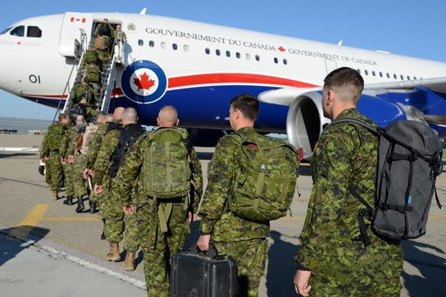
Canadian Armed Forces Search and Rescue
Canadian Armed Forces Search and Rescue (CAFSAR ) is the collective name used to refer to search and rescue resources and operations within the Canadian Armed Forces. CAFSAR is currently the responsibility of the Royal Canadian Air Force.
SAR System Funding
Largely as a result of the MH370 incident, which was an SAR fiasco, ICAO initiated an in-depth audit of the global SAR systems. The audit reviewed several incidents where SAR activities were substandard, and the major “excuse” from several states was “lack of financial resources.”
The following is an excerpt from this ICAO audit. Note the italicized sentences that may be useful in discussing the high costs of effective SAR operations, especially in large expanses of sparsely settle areas.
“The level of funding provided for effective SAR systems is a matter of concern for all senior decision-makers. The resources should be sufficient to develop and/or maintain the required SAR service per their obligations as signatories to the relevant aeronautical and maritime SAR conventions. This may require the development of business cases to governments outlining where additional funding is required.
Such business cases should include consideration of amendments to existing national SAR arrangements which may provide more efficient delivery of the SAR service by better utilization of existing resources (for example by establishing Joint RCCs (JRCCs), or additional fundingsources where required (for example charging a levy to aircraft operators for providing the SAR service).”
A final point of discussion is the polar continental shelf.
Polar Continental Shelf Project (PCSP)
The PCSP was created in 1958 in response to growing interest in Canada’s Arctic offshore areas. Activities in the Canadian Arctic developed at a rapid pace after the Second World War. Notably, five Canada/US weather stations were constructed in the Arctic islands in the late 1940s, followed by the Distant Early Warning (DEW) line of radar stations in the 1950s to support Cold War defence programs.
There were also sovereignty considerations driving the need for an organization like PCSP. Canada’s natural resource and exploration rights had been extended to its continental shelf area in the late 1950s. The PCSP’s dual mandate was to survey Canada’s Arctic continental shelf and to ensure proper jurisdiction over its natural resources.
The PCSP’s mission is to provide safe, efficient and cost-effective logistics in support of science and government priorities. The program provides logistics throughout the Canadian Arctic for field research that is conducted by Canadian government.
Additionally, the Program provides specific field logistics support for the Canadian Armed Forces Arctic Training Centre that is hosted at the PCSP facility in Resolute, Nunavut.
The PCSP can offer planning, coordination and delivery of the following Arctic logistics:
- Charter air transportation to and from remote field camps throughout Canada’s North;
- Field equipment for loan (including cold-weather clothing and communications equipment);
- Fuel for aircraft, field equipment and camps;
- Meals, accommodations and working space (including a multi-purpose laboratory) at the PCSP facility in Resolute, Nunavut (open from February to September);
- Scientific licensing and permitting advice;
- Advice and coordination for shipping and receiving (including sealift and dangerous goods); and
- A communications network that links the PCSP with the research teams in field camps dispersed throughout the Arctic
Through this work, the PCSP directly contributes to the exercise of Canadian Arctic sovereignty. This should fit in nicely to northern search and rescue requirements of the future.
Future Enhanced Air Traffic Control in the North
On March 4th of this year, RUSI(NS) published an article about the Automatic Dependent Surveillance – Broadcast (ADS-B), a new surveillance technology designed to help modernize the air transportation system.
ADS-B will have a significant impact on search and rescue operations especially in the high Arctic. Aircraft will always be tracked and monitors will know exactly where an aircraft went down (the situation with MH370 would never occur again) so that our SAR crews will know exactly where to search. ADS-B gives the real-time picture if aircraft deviate from assigned flight profiles.
Acquiring ADS-B monitoring equipment would be appropriate if CAF Rescue Coordination Centres (RCC) want to use the latest new technology. It would make sense to establish and man ADS-B monitors in all our RCC. This will be a task for the government and DND to work out.
Conclusion
Canada is a large country with enormous airspace dimensions in the north. As more and more use of our land, sea and airspace become the norm in the near future, Canada must be prepared to control our own territory and with that responsibility is the need for a timely and robust search and rescue capability. We have explained the issues and now the subject of funding for this requirement must be addressed. RUSI(NS) can only expose the problem. Our politicians must provide the answers and resources.
A PDF of this paper is available here.
Murray Lee is a retired RCAF pilot with extensive experience flying fighters. Ed Young is a retired RCAF officer with extensive experience flying, instructing and as a SAR specialist. This work is the sole opinion of the authors and does not necessarily represent the views of the Canadian Department of National Defence, the Canadian Armed Forces, the Royal Canadian Mounted Police or the Royal United Services Institute of Nova Scotia. The authors may be contacted by email at: RUSINovaScotia@gmail.com.